 

LOCH ARD
LOCH LUBNAIG
RIVER LENY
CANNALS
DARK TUNNEL
THE AVON
|

|
LOCHS & RIVERS
Watch
out for more water ways to be featured, along with water levels. In
a few months time we hope to have a report on some accommodation in
and around Scotland. If you want a water feature listed give us a call.
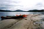
Loch
Ard is situated about 3 miles past Aberfoyle on the B829. OS map 57
Grid: 48640129. At the 'get in' there is ample space for a few cars
or a mini bus and trailer. Care should be taken when crossing the road
to gain access to the water as some of the cars whiz past. The actual
launch site is shallow and this is maintained for some distance into
the loch, instructors should take note of this when taking novices on
to the water. Once on the water a suitable area for gathering and making
sure the entire group is in fine shape, is by a cross. The cross is
situated about 30m from the waters edge on the left hand side. The cross
is there to advise water goers that shallow water surrounds the cross.
Once the group is on the water and ready to go, a suitable journey can
be to take the group to 'castle rock' why castle…. well why don't you
go and find out for yourself. Around Castle rock are other small islands.
These can be used quite effectively incorporating various games etc.
Depending on the size of your group, abilities and weather conditions
you can paddle a further way up the loch to another island. This island
has a better landing site and a small building on it. Its disused and
run down, so don't let any one in it, just in case. This could be a
good spot for lunch providing that you did not stop at Castle rock on
the way round as this would take up some time. From here the group has
normally had enough and looking forward to getting back. A short time
and your back at the start. Take care if the conditions are windy. If
the group are complete novices you can address this quite close to the
'get in', however mind the shallow areas.
Overall verdict: Lovely location; good for beginners and intermediate
flat-water paddlers. If the weather is nice you should have a good
days paddling.
HOME
LOCH
LUBNAIG
Loch
Lubnaig is situated about 4 miles west past Callander, on the A84. The
official SCA launch point is about three quarters along the Loch (from
Callander). The site is not the ideal site to launch from and leaves
a lot to be desired as a launch point, not only as to the land-based
hazards but also on the water. This is due to close by reeds and the
like and in a moderate wind where do the boats get blown? Yep… the reeds.
Don't worry all is not lost. There are a few car parks on the Loch side
at the Callander end. The first one is where we tend to launch from.
The car park has had in the past a height restricted barrier. Its not
there at the moment, however keep an eye out before you go whizzing
into the car park. Once in the car park there is ample space to move
around and get changed. The area around the car park and the actual
water way is pebbled, so watch the wee ones don't trip up. The get in
is quite shallow and is like this for a few meters in depending on exactly
where you launch. Hazards in the area are under water from people throwing
bottles and cans in to the water. Make sure adequate footwear is worn.
The surrounding water at the get in is suitable for coaching. The Loch
although surrounded by spectacular scenery is quite featureless. You
could paddle to the other end. Bare in mind it's a bit of a jaunt and
not a good idea for complete novices. The initial get in is good and
depending on the group you can have a good time. Watch out for lots
of people taking your picture as there are loads of tourists especially
in the warm weather.
Overall Verdict: Nice Location depending where you launch. Restricted
in features. Good area for coaching.
HOME
THE
RIVER LENY
The
River Leny is situated about 2/3 miles past Callander on the left hand
side heading up the A84. The river could be graded 4/5, depending on
the water level. Particular attention and respect should
be paid to the 'falls of Leny'.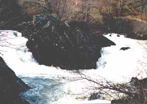
The
lenny Falls, normally shot on the river left. However great care
should be taken.
The
falls can come all to quick, depending on the level and you could end
up in a world of trouble. The river is essentially Loch fed, and a variety
of 'get ins' are afforded; however the A84 is a fast and windy road
so use the appropriate parking areas. The 'get in' at the top (OS map
57 grid 5864 0959) starts kind of slow and can lull the naive paddler
into a false sense of security. As you pass under the first bridge the
chaotic water starts. Not to heavy, G2 and leads onto a fast moving
section before the fun starts. From under the first bridge to just short
of the falls the river warms from G2, flat fast turbulent, G3 (G4 in
high water). There are a few good play areas on the right and center.
Some stoppers provide the river with some playthings to keep it occupied.
There's always a nagging doubt and lack of commitment in some paddlers
when being played by the river. The psychological thingy in the back
of the mind is always trained on the approaching falls. The prospect
of playing and accidentally swimming towards the falls is thought
provoking. The key to spotting the falls is watching the bridge remains
go past on both sides. At the very last there is usually room on the
river right for two paddlers to eddy out. From there a visual inspection
of the 'last gasp' eddy on both sides of the river can be obtained
(I usually go for the river left). From the bridge remains if you
reckon that it is clear go for either 'last gasp' eddy. Its good practice
to send a more experienced paddler down at this stage, once he/she
has made it they should exit the boat and get ready with a rope. Once
your group has made it and they're suitably pumped up by just making
the eddy they can proceed with caution and walk down the bank (river
left) to inspect the falls. A good friend once said,
"The
time spent looking at a stopper or rapid prior to shooting it is directly
proportional to The time spent getting trashed in it."
So this
is your time to decide. Portage can be made on the left or right, just
be careful. After portaging, swimming, getting thrashed or eloquently
paddling the falls a short run of about 300/400 meters to the 'wee stinker'
followed by the 'essess'. These rapids are G3 (G4 in high water) and
are good fun. Why is the 'wee stinker' so named? Well after paddling
so eloquently on the falls you might think your bomb proof…think again.
A nice little G2 run down to the Laid inn at GR 6081 0828 and egress
is made. You can paddle on down to Callander to the large car park (not
so when the river is in the main street (hee hee)). Watch your route
this way. In high water the route is not always straightforward and
trees are a big hindrance, be warned.
Overall Verdict: A very demanding river and the falls can be a real
challenge. Some nice play spots (but I'm not telling you where they
are). Clean water. Good access and egress. Few trees unless you go
from the Laid to Callander. For Intermediate and above paddlers.
HOME
CANALS
IN THE AREA
Both
the Forth and Clyde and Union Canal are easy access for the Stirling
area and are excellent for training and coaching. The Union Canal starts
at Edinburgh and finishes in Falkirk where many years ago it was linked
to Forth and Clyde Canal (There is a plan to restore this link). On
the Forth and Clyde there are a good few miles of paddling from lock
16 to High Bonnybridge and from High Bonnybridge to Allandale without
the necessity to portage locks. However, trips on the Forth and Clyde
are uncertain just now because the work going on for the millennium
project to restore navigation could mean a total lack of water. The
Union Canal is the better prospect just now. The Union is a contour
canal with no locks to portage and can almost be navigated in its entirety
to Edinburgh. Some portages are necessary at present due to the construction
of bridges for the millennium project. The only other problem can be
the amount of surface weed, which grows prolifically in the summer months.
The following two trips are favourites of the club.
HOME
THE
DARK TUNNEL
Travelling
into Falkirk from the West at the Beefeater Restaurant, Rosebank, turn
right, heading south up the Forth and Clyde canal. After about a mile
you reach the end of the union canal. Car parking is limited here so
if you have a big group, park in one of the car parks that you will
have passed on the way up. Put in here and just over a mile you will
reach the "Dark Tunnel". This tunnel is ˝ a mile long and runs from
Falkirk high station to Glen village. A head torch is useful on this
trip to aid your navigation and help you appreciate the work involved
in the construction of this tunnel. Continuing eastwards from tunnel
takes you under "The Laughing Greetin Brig". On the keystone of this
bridge there are carved faces depicting, as local legend has it, the
contractor who went bankrupt while almost completing this section of
the canal and the contractor who finished the section and received payment
for the others work. The trip can be of any duration suitable to the
group ability and fitness. Returning to the start alleviates any logistic
problems.
THE
AVON AQUADUCT
The
starting point is East of Polmont, with a bit of logistic organisation
this trip can be terminated at Linlithgow basin or simply return to
the start. To find the start, leave the M9 motorway at junction 4 and
head south on the A801. After ˝ a mile there is a car park on the left,
just before you cross the canal (at present the Road Bridge over the
canal is being reconstructed). Head eastward for just over mile and
you will pass Muiravonside kirk. On the right you will pass a large
basin, this was used to load coal which was delivered by rail from the
local mines. The next point of interest is the Avon aqueduct. This magnificent
construction carries the canal over the river Avon gorge and is well
worth a stop to inspect and admire the views. Carry on as far as the
ability of the group then return to the start or continue to Linlithgow
if you have organised transport.
HOME
POLO
ACCOMODATION
COACH LOCHS
|